17.5 °c Wind speed: 13 km/h Precipitation: 30 % Cloudiness: 71 % Humidity: 90 mm Pressure: 30 mb
Sally Gap
Sally Gap
WW
Ireland


Description
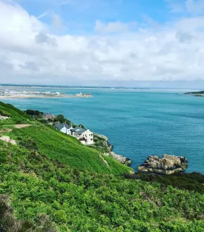
Sally Gap is undoubtedly one of the most gorgeous places near Dublin. It is among the first places tourists visit on their journey around the island. As soon as you start navigating the narrow road to Sally Gap, you quickly realise this will be an unusual road trip. And even though this area is on every itinerary, the road is mostly deserted, and you will meet only a few cars there. Whether you’re chasing a peaceful escape or cinematic landscapes, this drive promises to linger in your heart long after you leave.
Scenic “spin”
The Sally Gap is a mountain pass at 503m above sea level, one of the passes through the Wicklow Mountains. The official name for the road is the R579, which is for those of you who may try to locate the area on Google Maps. The Sally Gap can be accessed from Laragh, Roundwood, or Enniskerry and provides a more impressive alternative route to the M50 for travellers to Dublin. If you’re looking for a scenic “spin” (Irish colloquial speak for a drive!) on your trip to Ireland, the best route is through the Sally Gap in Co. Wicklow.
The step will lead to Powerscourt. Powerscourt House and Gardens and the nearby beautiful Powerscourt Waterfall. Then, you can follow the L1011, a typical rural Irish rode, to Glencree. Not that far from Glencree, explore the lovely Lower Lough Bray and Upper Lough Bray. Before reaching the lake viewpoints, stop at the P.S. I Love You Bridge, less than three kilometres from Sally Gap. This short stop is primarily for movie fans or those who want to stretch their legs. The lakes are far away, so you might consider exploring this area on foot for better views. The colour of the water changes from deep blue to inky black depending on the weather, and the contrast with the surrounding greenery is striking! Then, continue to Sally Gap. Once you reach Sally Gap, you must decide on your next move. You can turn left to Roundwood, turn right to Blessington, travel back to Dublin or continue to Glendalough.
Glimpse into history
The Sally Gap Drive is packed with great attractions and stops that emphasise the history and beauty of Wicklow. The British Army constructed the road along the Sally Gap after the 1798 rebellion. It was built between 1801 and 1809 to help the British Army travel quickly across this area, fight against the rebels, and restrict their movement. The road aimed to allow the British to travel rapidly through the Wicklow Mountains, hunting down rebels of the United Irishmen who had retreated.
Today, the road along the Sally Gap is still called the Military Road. The 60-kilometer highway stretches from Rathfarnham (in Dublin) to Aughavannagh. The view from the road along the gap is extensive. Once, this lengthy view used to serve only to benefit British soldiers seeking out the enemy; today, it offers tourists the finest scenery in Ireland. The highest point, standing at 503m above altitude, is where it crosses the R115 Military Road (R115). Can you feel your ears popping already?
We have mentioned it numerous times, but we can not stress how incredible the scenery along the Sally Gap is. As you travel along the route, you will take in the valley of the River Liffey, the moors of the Sally Gap plateau, Kippure Mountain, the Glenmacnass Waterfall, Glencree Valley and the deep Lough Tay Lake. As if this isn’t enough, you’ll also take in the wild peaks of the Wicklow Mountains, carpets of purple heather and patches of blanket bog. Some remarkable tourist attractions along the way include the Glencree German War Cemetery and The Glencree Visitor Centre for Peace and Reconciliation.
Stops along the road
All in all, the Sally Gap is an hour-long drive. Given all that has been said above and considering what other visitors to the area have to say, it is worth taking an hour out of your trip to take in the views this route offers. When visiting, don’t forget to take some time to get out and walk around the trails surrounding the gap to grab some amazing photographs you won’t get anywhere else in Ireland.
Put a drive through The Sally Gap on your Irish bucket list for breathtaking views and an awesome mini road trip in the beautiful Co. Wicklow! You can stay overnight at Glendalough, a small village in the countryside. Founded by St. Kevin, this early 6th-century Christian monastic settlement with its Round Tower is the site's highlight.
A fantastic stop at the end of the Sally Gap Drive is The Wicklow Heather, a restaurant in the lovely village of Laragh. The menu features organic, locally sourced produce, including signature dishes such as duck confit with Clonakilty black pudding, pan-fried chump of Wicklow lamb, and Wicklow Hereford beef.
The road offers a beautiful but relatively challenging climb to Sally Gap, perfect for enthusiast cyclists. Be prepared for cycling in windy and cooler weather, and be careful when going downhill. A rule of thumb is to drive slowly and pay attention to oncoming traffic. The scenery along the Sally Gap is worth the hardship of the drive—trust us on this one! Be prepared for some very winding roads and tight squeezes on the route. Moreover, winter can sometimes complicate the road.
Depending on your pace and itinerary, visiting Sally Gap and driving the Old Military Road takes about one to two hours. It allows you to travel at your own pace and make as many stops as you want along the way. Since there are plenty of stops along the way, having a car in this area is an obvious advantage. We advise to visit Sally Gap on foot, after parking your car in the designated parking lot. To get one of the most magnificent views you’ll ever see in Ireland, it’s best to go there on a clear day. The difficulty level is very low, and the walk does not require a high level of hiking. Unfortunately, there is no public transport to Sally Gap.


Comments